
Mapping Farms and Forests: Inside the Landscapes Powering Global Food Systems
By Fahmi Faridz, March 2026
Where are the world's food systems actually taking shape? On farms and in forests that someone has to map.
Our latest data deep dive looks at what the Solstice platform (https://solstice.world) is revealing as organizations map agricultural and forest landscapes across 40+ countries.
Some highlights:
Over 23,000 farm sites and 6,000 forest sites have already been mapped, covering more than 50,000 hectares. That's roughly the size of Andorra.
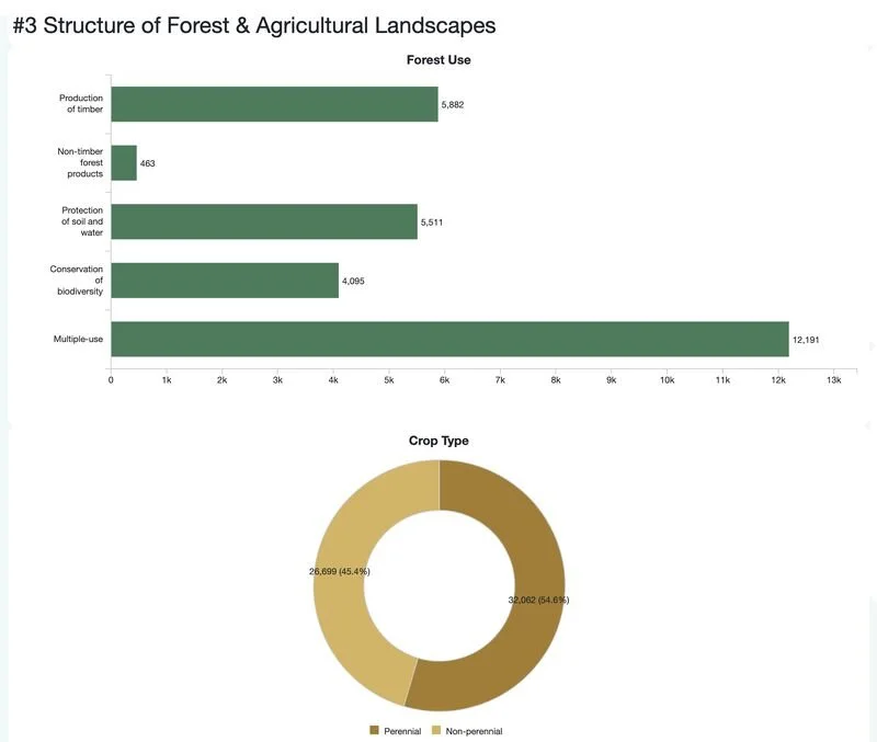
Forests cover far more area per site than farms, but farms outnumber forests nearly 4 to 1. The structure of the data tells a story about how land is actually managed.
The biggest forest category? Multiple-use landscapes combining timber, conservation, and community benefits in the same area.
And this isn't a one-time upload. The time series shows steady growth month over month as field teams keep adding sites across regions.
World Vision International is one of the organizations leading this work globally through its Environmental Sustainability and Climate Action strategy.
Food systems transformation needs visibility. You can't improve what you haven't mapped.
Read the full deep dive: https://lnkd.in/gRih_kii
#FoodSystems #Sustainability #LandscapeMapping #Solstice #mWater