
National water monitoring software for governments
mWater: One national system for water-sector data and operations.
Governments in more than ten countries use mWater as part or all of their national water monitoring system. The platform is free for unlimited standard use, at any scale, with no per-user fees and no licensing costs after a project ends.
mWater is a national water monitoring and management information system for governments, water authorities, regulators, and utilities. One platform holds the national inventories, the field data, the maps and dashboards, and the daily workflows. It covers water resources, water supply services, institutional WASH, utility operations, water quality, assets, regulation, and reporting, and it exchanges data in both directions with sensors and other government systems.
Who uses it
National water monitoring on mWater is built for the public agencies that carry legal responsibility for water services and water resources. Our government users include:
- Ministries of water, health, environment, and local government
- National water and sanitation regulators
- National and municipal utilities and rural service providers
- Provincial, district, and county water offices
- National planning and statistics units that report on sector indicators
- Development partners funding or supporting a government-led system
What a national system on mWater covers
A national water information system usually starts with one dataset and grows. mWater holds all of the following in one place, so that a district officer, a regulator, and a minister look at the same records.
| Domain | What mWater manages |
|---|---|
| Water resources | Site-based hydrometeorological data, hydrogeological data, well logs, water use permits |
| Water supply services | National water point and scheme inventories, functionality, service levels, population served |
| Institutional WASH | Schools, health facilities, and public institutions |
| Utilities | Key performance indicators, customer records, meter reading, fee collection, accounting, operations and maintenance |
| Water quality | Sampling, laboratory results, compliance criteria, mapped compliance status |
| Assets and infrastructure | Asset registries, condition, maintenance history, work orders, investment planning |
| Regulation | Inspections, licensing and permit applications, complaints, service level agreements |
| Monitoring and evaluation | Indicator libraries, national reporting, program dashboards |
Ministries name these systems differently. A national water information system, a WASH management information system, a water sector MIS, and a water asset management platform all describe work that mWater does on one platform.
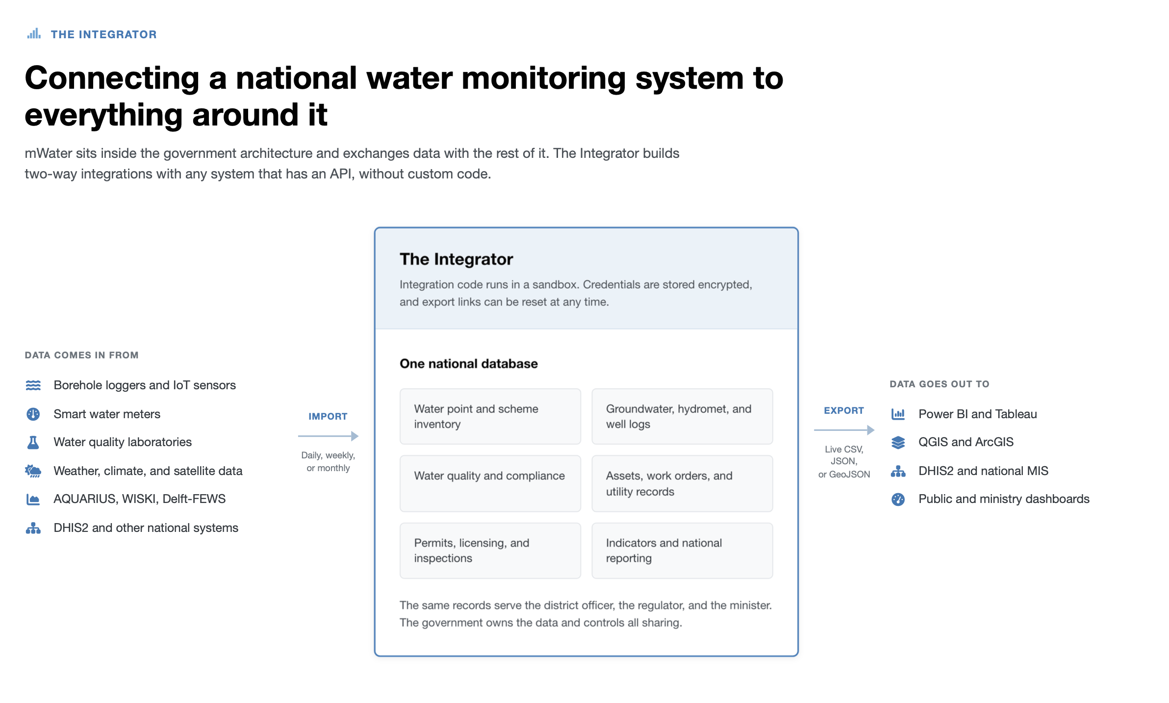
It connects to the systems you already run
The mWater Integrator builds two-way integrations with any system that has an API, on a daily, weekly, or monthly schedule, without custom code and without an engineering contract. You describe the data you need in plain language, and an AI assistant inspects the external API, writes the integration, and maps the data to the right tables. Integration code runs in a sandbox, credentials are stored encrypted, and export links can be reset at any time.
Agencies already use the Integrator to bring in borehole water level logger readings, smart meter consumption, water quality laboratory results, IoT flow, pressure, and turbidity readings, DHIS2 health indicators, national MIS datasets, weather and climate data from meteorological APIs, satellite drought and flood indicators, and financial transactions from accounting software. It also works in the other direction. Any dataset in mWater can be published as a live CSV, JSON, or GeoJSON endpoint that Power BI, Tableau, QGIS, ArcGIS, DHIS2, or a national MIS pulls from whenever it needs current figures. The Integrator was funded by UNICEF Madagascar and is free for every user. Read how the Integrator works
For high-frequency hydrometric telemetry, rating curves, and hydrological time series modeling, specialist software such as AQUARIUS, WISKI, and Delft-FEWS remains the right tool, and mWater is designed to work with it rather than replace it. Gauge readings and forecast outputs come in through the Integrator or the API and sit alongside the national inventories, service data, water quality results, and permits that mWater manages. A national architecture can use both, and many do.
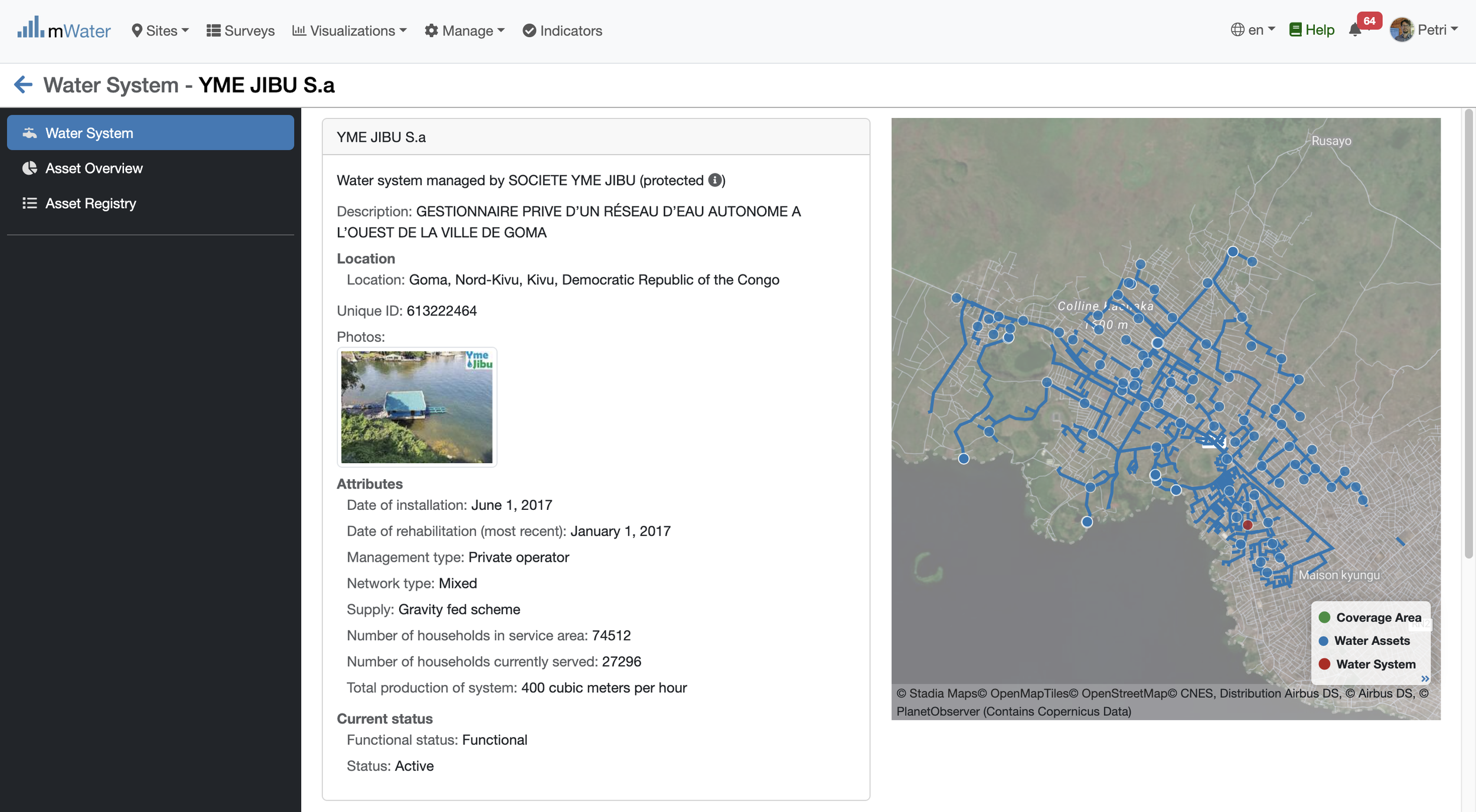
Example water scheme.
What the platform does
The table below answers the requirements that come up most often in national procurements.
| Requirement | mWater |
|---|---|
| Offline mobile data collection | Yes, on Android and iOS, with automatic sync |
| National site registry with GPS and photos | Yes, with unlimited photo uploads |
| Groundwater monitoring and well logs | Yes |
| Water quality monitoring with compliance rules | Yes, with a standard indicator library |
| Hydrometeorological data | Yes, site-based |
| Sensor, telemetry, and satellite data ingestion | Yes, through the Integrator and the API |
| Export to other systems | Yes, as live CSV, JSON, or GeoJSON endpoints |
| GIS and mapping | Yes, including shapefile and GeoJSON import and export |
| Dashboards and public portals | Yes, with a drag and drop designer |
| Permits, licensing, and inspection workflows | Yes, through Workflows |
| Utility billing, meter reading, and accounting | Yes, with customer records and a water supply planning module |
| REST API | Yes, subject to a fair use policy |
| Business intelligence tools | Yes, including Power BI and Tableau |
| Languages | 27 on the platform, with government-managed translation |
| Roles and permissions for many agencies | Yes, by organization, team, and custom workflow role |
| Audit log and data recovery | Yes, with activity logs and point in time recovery |
| Security | Encryption in transit and at rest, two-factor authentication, independent security audit in 2023 |
| Uptime | 99.985 percent in 2024 |
| Sensitive data handling | Yes, with a confidential data mode that limits responses to administrators |
| Support | Ticketing, resource center, and a four hour average first response |
| Open source | More than 70 percent of the codebase, operated as a Digital Public Good |
| Continuity | Source code held in escrow by international partners including WaterAid |
| AI access | Yes, through an MCP server with permission-aware queries and human approval of any change |
| Data ownership | The government owns its data and controls all sharing |
| Cost of standard use | Free, unlimited, with no vendor lock-in |
Governments already running national systems on mWater
Here are three active examples:
Papua New Guinea. The Department of National Planning and Monitoring leads a national WASH monitoring system built on mWater. It brings community, school, health facility, and project data together to guide planning and investment. Read the case study
Uganda. The Ministry of Water and Environment runs RUMIS, the Rural and Urban Management Information System, for nationwide management of water data. RUMIS connects field data to shared information for local, district, and national government, and supports asset mapping, service monitoring, and daily management. Read the case study
Zimbabwe. The Ministry of Health and Child Care brings drinking water quality, sanitation, and institutional WASH monitoring together in its mWater-powered management information system. Explore the government portal
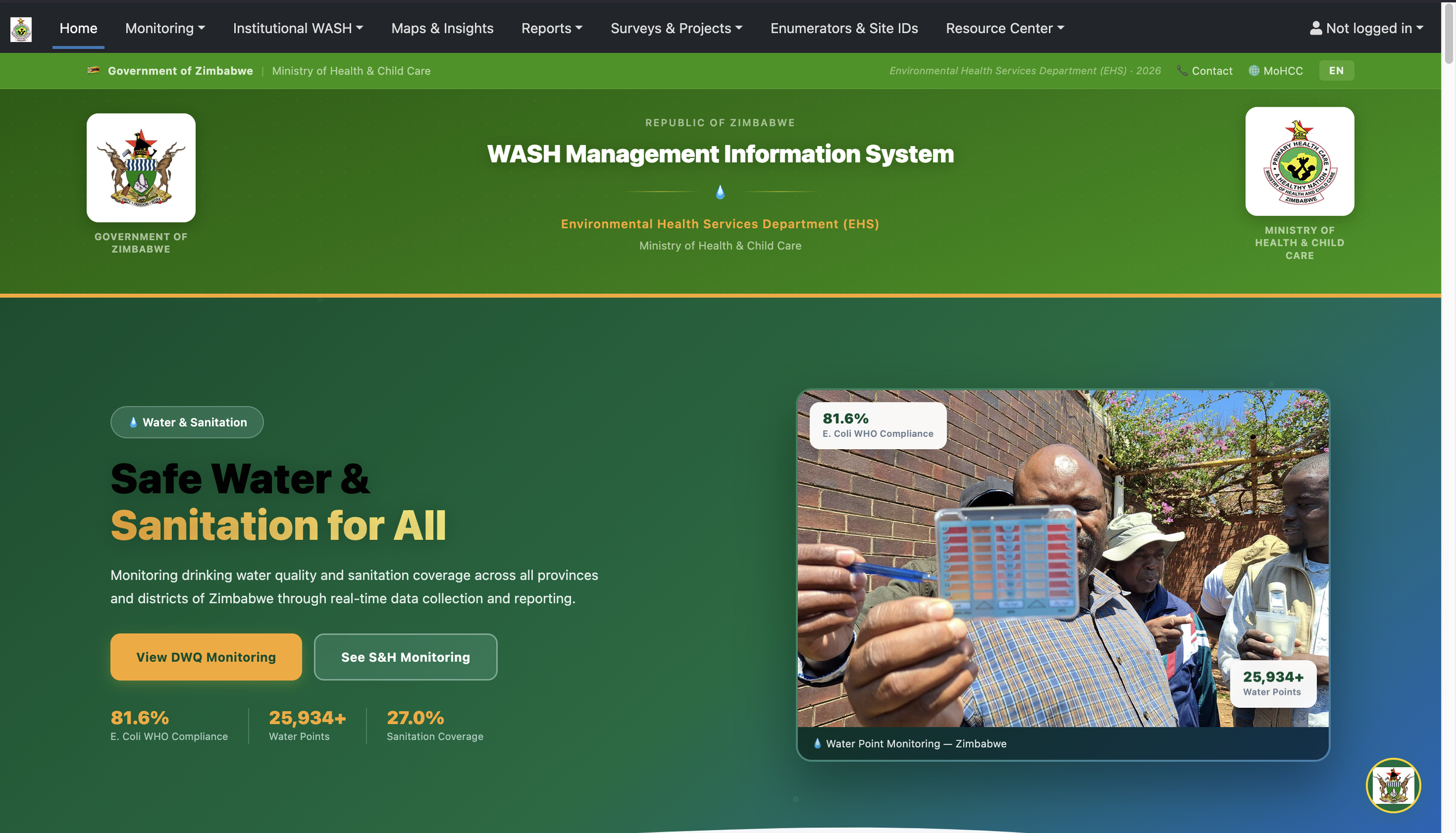
Zimbabwe's WASH Management Information System.
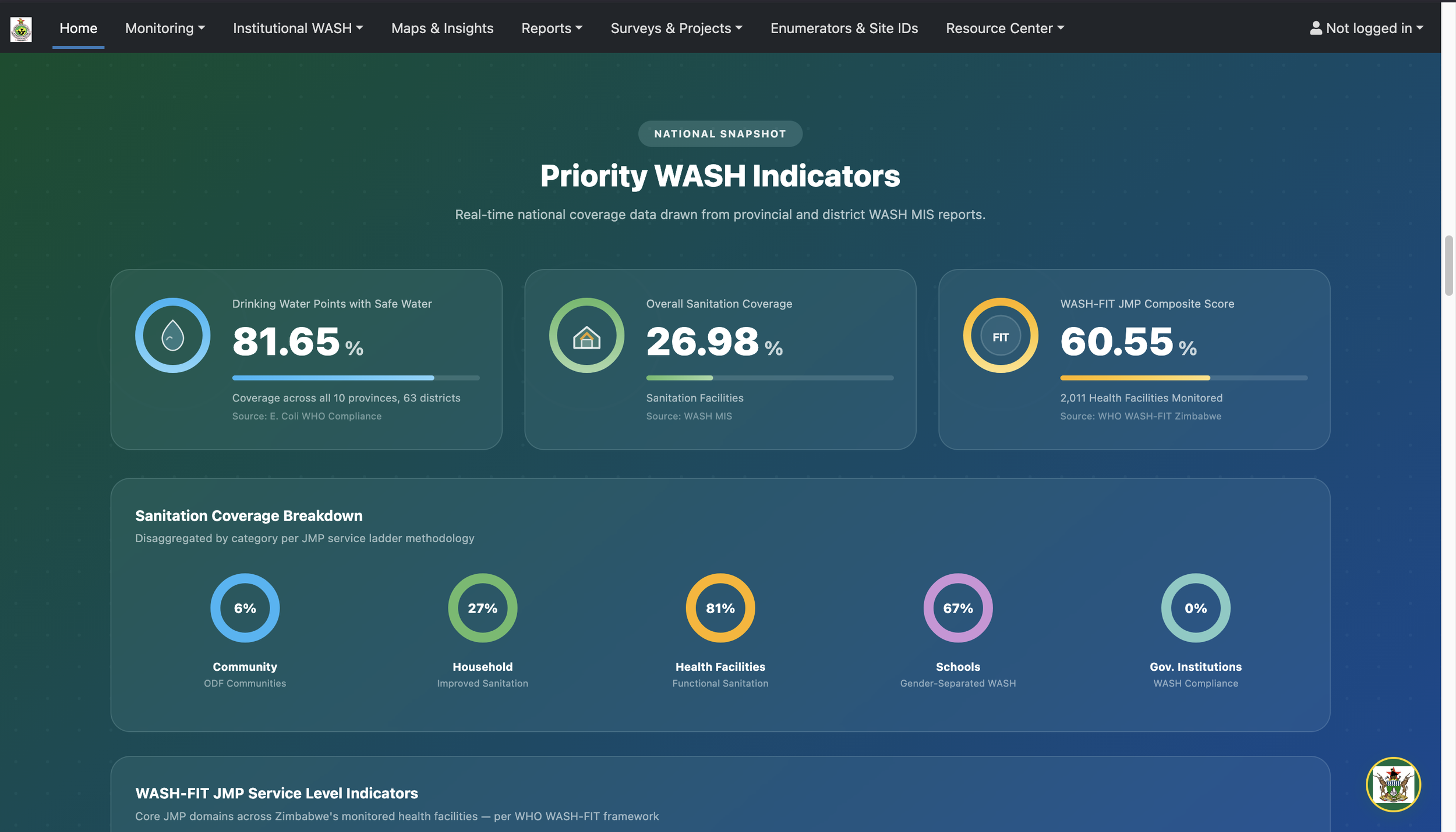
Priority WASH Indicators derived from real-time data collected with mWater.
In Angola, we are building a system with UNICEF and three ministries that unifies WASH, climate, and disaster risk data. In Haiti, the national water and sanitation authority DINEPA standardized utility reporting on assets, customers, and financial performance. Governments in Indonesia, Guinea-Bissau, Malawi, and Kenya run national or subnational systems on the platform as well. See all projects
How a national deployment works
Any government can start using mWater today at no cost, and many do before they ever contact us. You can sign up, build a form, and collect data the same week.
For an official national system, we work with the ministry or authority that will own it. The usual sequence is a review of the datasets and reporting the agency already has, a system design agreed with those stakeholders, configuration of forms, dashboards, and workflows, training, and handover.
Training is sized to the role. Staff who collect data and read dashboards need about four hours. Staff who build surveys and analyze data need about sixteen. The administrators who will run the system without us need about forty. We usually deliver this in person, three days at a time.
The aim throughout is a government team that maintains and extends the system itself. Because the platform is free and open, the government continues to operate it without licensing costs or dependence on outside specialists. See the national MIS support tier
What it costs
All standard features of mWater are free for unlimited use, including unlimited forms, users, surveys, and integrations. Governments pay only for the services they choose, such as MIS design, training, and support, and that work is normally funded by a development partner. When the funding ends, the system keeps running.
Why it is free, and how is the service sustained
Agencies reasonably ask what the catch is, and how a free system survives.
mWater is run by a non-profit and has operated continuously since 2012. Development is funded by contracts, grants, and service agreements with around twenty donors and clients, not by license fees, so the platform does not depend on charging governments to use it. When a partner funds a new feature, we build it and release it to every user. About 99 percent of our users operate without any direct contact with our team.
More than 70 percent of the codebase is open source, and mWater operates as a Digital Public Good. Parts of the code are held in escrow by substantial international partners, including WaterAid, so that the platform can continue if this organization cannot. Governments can export every record at any time through the API, so leaving is always possible.
Common questions
Governments and their advisors ask us the same questions in most procurements. Short answers follow, and our team is glad to go further.
Can mWater run a national water information system? Yes. It is part or all of the national water monitoring system in more than ten countries, and 30 or more national, regional, and local agencies work with us directly.
Does it work without internet? Yes. Field staff collect data offline on phones or tablets, and records sync when a connection returns.
Can it exchange data with our existing systems? Yes. The Integrator builds two-way integrations with any system that has an API, without custom code, and mWater also has a REST API and imports and exports common spatial and tabular formats.
Can it take sensor and satellite data? Yes. Borehole loggers, smart meters, IoT sensors, weather APIs, and satellite drought and flood products all import on a schedule you set.
Do we have to replace our hydrological or health information systems? No. mWater is designed to run alongside systems such as AQUARIUS, WISKI, Delft-FEWS, and DHIS2 and to exchange data with them.
Who owns the data? The government does. Users decide what is public, protected, or private, and can export everything at any time.
How large can it get? The platform holds more than 7.5 million water and sanitation sites and 50 million survey records worldwide, and serves over 390,000 users and thousands of organizations across 199 countries and territories.
Talk to us about your national system
If your agency is planning a national water monitoring system, we can share terms of reference, sample statements of work, and cost estimates from comparable programs. Write to info@mwater.co, or contact us here. You can also sign up for the free platform and begin today.